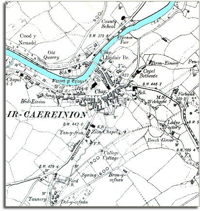
The map below is a section of a map made at a scale of 6 inches = 1 mile in 1902. It is more detailed than the 1836 map of the town and we can see more of the buildings and some of the changes which have come during the long reign of Queen Victoria.
| Llanfair Caereinion in 1902 | ||
|
The map below is a section of a map made at a scale of 6 inches = 1 mile in 1902. It is more detailed than the 1836 map of the town and we can see more of the buildings and some of the changes which have come during the long reign of Queen Victoria. |
||
|
||
| The
town is still a small market town with the parish church at its heart. The
church has been rebuilt during Queen
Victoria's reign and looks a different shape from the 1836 map. There are also many chapels in the town now offering local people another way of worshipping. These chapels also organised many other activities for their members and many conducted all their activities in the Welsh language and so helped preserve the language and traditions. |
||
| There are three schools marked on the map (Two marked Sch). By the time of this map all children had an education, even those from the poorest families. This meant they had more opportunities when they grew up. The more able children could attend the County School and possibly go on into the professions. In 1902 there were still many families who could not afford to let their children stay on at school so long though. | ||
| Compare with the map of the town in 1836 |