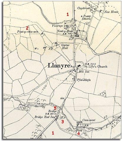
The map below is a section of a map made at a scale of 6 inches = 1 mile in 1902. The map shows us some of the changes which have come to Llanyre during Queen Victoria's long reign.
| Llanyre in 1902 | ||
|
The map below is a section of a map made at a scale of 6 inches = 1 mile in 1902. The map shows us some of the changes which have come to Llanyre during Queen Victoria's long reign. |
||
|
|
|
|
| 1. The commons to the North and South of the village have been enclosed. This land probably was probably more productive enclosed in new fields but this meant that local farm workers could no longer graze animals on the common. | ||
| 2. The tithe map of 1840 shows the tiny holding called "Brynhorkin" at this point. By the end of the Victorian period it has completely gone. | ||
| 3. and 4. Likewise the two smallholdings by the stream at this point have disappeared. The occupiers probably moved away to try to make a better life elsewhere | ||
|
5. The mill and millpond which stood by the stream near Llanyre bridge have both disappeared and the Bridge End Inn has been built. |
||
| Compare with a map of the area in 1840.. | ||
|
|
||