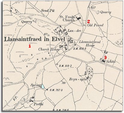
The map below is a section of a map made at a scale of 6 inches = 1 mile in 1902. Although the community looks very similar to how it did in 1839 there have been some changes during Queen Victoria's long reign.
| Llansantffraid-in-Elfael in 1902 | ||
|
The map below is a section of a map made at a scale of 6 inches = 1 mile in 1902. Although the community looks very similar to how it did in 1839 there have been some changes during Queen Victoria's long reign. |
||
|
|
|
|
| 1. In 1839 this large field was three separate fields. During Queen Victoria's reign it has been made into one large pasture. | ||
| 2. In 1839 there was a small farm called Upper Landre at this point. At some time during the Victorian period it has been abandoned and fallen into ruin. Now there is nothing marked on the map here. | ||
|
3. The parish now has a school. This meant local children got an education and new possibilities when they grew up. |
||
| Compare with a map of the area in 1837.. | ||
|
|
||