Llandrindod and district
Some Victorian maps
  Llansantffraid-in-Elfael in 1837  
 

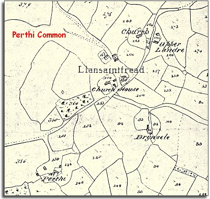
The map below is based on the tithe map for the parish of Llansantffraid-in-Elfael and it gives us a good idea of the layout of the houses, farms and fields at the beginning of Queen Victoria's reign.


TITHE MAPS
In Victorian times almost everyone had to pay tithes to the Church of England. At the beginning of the reign the tithe became a tax on your property. The maps were drawn to see what property everybody had
 

Like many communities in Radnorshire Llansantffraid is not really a village but a scatter of farms and holdings with just a couple of houses by the church. As the church is on high ground some of the land around it is not enclosed but open common.
Although the parish was sparsely populated, in 1841 it had a grocer, a surgeon, a weaver, a blacksmith, a shoemaker and a dressmaker among others.

 
  Compare with a map of the area in 1902..  
 

Back to Llandrindod maps menu..

Link to sources
Back to top
Back to Llandrindod menu