| |
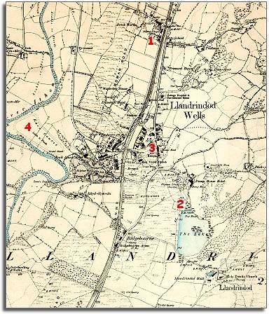
Running down the middle
of the map is the new railway line which
made the development of the new town possible. The railway brought in large
numbers of visitors to take the waters and hotels
and guest houses were built for them. |
|
| |
1.
At the north end of the new town is the new settlement where the road
crosses the railway and a new National
School building has been built there. At this time there was a big gap
between this crossing area and the town centre.
|
|
| |
2.
Just to the south of the Pump House Hotel a new
lake has been dug out of boggy ground by the hotel for the guests
to the town to enjoy. |
|
| |
3.
Temple Gardens is still part of the open common. Walking from
the Bridge Hotel to the Ridgebourne in 1887 you would have walked across
open common with no houses. |
|
| |
4.
Down in the meadows by the river you can see a race
course. This was another development designed to attract visitors.
|
|
|
As the railway
came in the 1860s when the open common was enclosed we can see that an awful
lot has been done in a short time. This is still very different from the
Llandrindod Wells we know today, though. There are no
buildings on the east side of Middleton Street and where the
large Post Office building is today there is a field! |
|
| |
Compare
with a map of the area in 1833.. |
|
| |
Back to Llandrindod
maps menu..
|
|
|
|
|
|