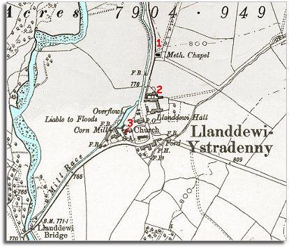
The map below is a section of a map made at a scale of 6 inches = 1 mile in 1902. Although the villagelooks very similar to how it did in 1839 there have been some changes during Queen Victoria's long reign.
| Llanddewi Ystradenni in 1902 | ||
|
The map below is a section of a map made at a scale of 6 inches = 1 mile in 1902. Although the villagelooks very similar to how it did in 1839 there have been some changes during Queen Victoria's long reign. |
||
|
|
|
|
| 1. A Methodist chapel has been built on the roadside. During the 19th century the "nonconformist" denominations (Methodists, Baptists, Congregationals etc) grew in popularity. By organising their own chapel communities local people felt more closely involved with their religion. | ||
| 2. Llanddewi Hall has expanded and built a timber yard. Here local trees could be cut up into timber for sale. | ||
|
3. Perhaps the most important change is the new village school. Although there was a schoolmaster in the village in 1839 few children from poorer families would have attended school. By the end of Victoria's reign all children in the parish had an education, even those from the poorest families. This meant they had more opportunities when they grew up. Instead of having no possibility of a life anywhere but working on the land, children were given enough education to enable some of them to do something different with their lives. |
||
| Compare with a map of the area in 1839.. | ||
|
|
||