Llandrindod and district
Some Victorian maps
  Llansddewi Ystradenni in 1839  
 

The map below is based on the tithe map for the parish of Llanddewi Ystradenni and it gives us a good idea of the layout of the village in the early years of Queen Victoria's reign.

The original map was not aligned with North at the top so we have turned it round to make it easier to compare with later maps.

TITHE MAPS
In Victorian times almost everyone had to pay tithes to the Church of England. At the beginning of the reign the tithe became a tax on your property. The maps were drawn to see what property everybody had
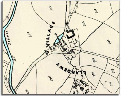
  From the map you can see that this community grew up by the side of this North road to Montgomeryshire. At the centre of the village you can see the mill pond for the local mill.  
 

Although the map shows us a very small village the 1841 census gives a picture of a busy community. Farming was of course how most families made their living and Llanddewi Hall at the centre of the map was occupied by farmer John Morgan.
Besides the farmers and farm labourers in the parish were;-
5 shoemakers, 4 carpenters, 2 blacksmiths, 5 masons, 1 sawyer, 1 wheelwright, 1 grocer, 1 builder, 1 clock and watch maker, 1 schoolmaster, 1 molecatcher and 1 grocer.
The Llanddewi Arms was run by publican Susanna Griffiths and her 4 servants. Lodging here at the time of the census was the local curate (assistant vicar) and a drover.

 
  Compare with a map of the area in 1902..  
 

Back to Llandrindod maps menu..

Link to sources
Back to top
Back to Llandrindod menu