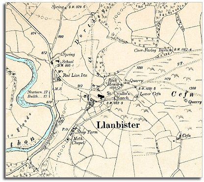
The map below is a section of a map made at a scale of 6 inches = 1 mile in 1902. Although Llanbister looks very similar to how it did in 1841 there have been some changes during Queen Victoria's long reign.
| Llanbister in 1902 | ||
|
The map below is a section of a map made at a scale of 6 inches = 1 mile in 1902. Although Llanbister looks very similar to how it did in 1841 there have been some changes during Queen Victoria's long reign. |
||
|
|
|
|
| The
tollgates have gone from the main road and travel
is easier for poor people. Even so many local farm workers and
their families lived throughout the period without travelling more than
just a few miles from where they were born.
A school is marked on the map on the bank above the road. By the end of Queen Victoria's reign all children had to attend school and this did give the more able children the chance to get a better education and perhaps go on to a better job when they grew up. Compare with a map of the area in 1841..Back to Llandrindod maps menu..
|
|
|