Llandrindod
and district
Some Victorian maps
Llanbister in 1841 | ||
The map below is based on the tithe map for the parish of Llanbister and it gives us a good idea of the layout of the village at the beginning of Queen Victoria's reign. |
The
original map was not aligned with North at the top so we have turned it
round to make it easier to compare with later maps.
|
|
TITHE MAPS In Victorian times almost everyone had to pay tithes to the Church of England. At the beginning of the reign the tithe became a tax on your property. The maps were drawn to see what property everybody had |
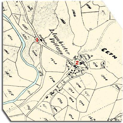
1. The tithe map shows the tollgate on the turnpike road to Newtown. To take any animals through the gate you would have to pay a toll. At the time this map was made William Bounford lived here with his family. He worked on a farm locally so it was probably his wife who collected the money and opened the gates. | ||
2. The village itself with its houses clustering along the hillside by the church. In 1841 there were 2 seamstresses making and altering clothes, 2 shoemakers, 1 tailor and 1 mason. According to the census records a carpenter and his apprentice lived in the village at Frog Street. The grocer was Francis Woosnam aged 70. | ||
A
mystery! |
||
Compare with a map of the area in 1902.. |
||