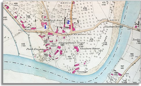
The image below is based on an Ordnance Survey map published in 1887 at a scale of 6 miles = 1 inch. The overall shape of the community has not changed that much though there have been changes to peoples lives.
| Glasbury in 1887 | ||
|
The image below is based on an Ordnance Survey map published in 1887 at a scale of 6 miles = 1 inch. The overall shape of the community has not changed that much though there have been changes to peoples lives. |
||
|
|
|
|
| 1. The Maesllwch Arms is still an important Inn standing at the bottom of the drive to Maesllwch Castle itself. In the 1890s the Landlord was John Curtis Morgan. Inns like the Maesllwch Arms were still very important to travellers in the late Victorian period. | ||
| 2. Alongside the road to Clyro you can see a timber yard and saw mill. Big estates often set these up to turn the felled trees from the estate into timber for the building industry. carefully managed woodland on an estate could be very profitable. | ||
|
A business directory from around
1890 lists some of the craftsmen and traders working in the community
at that time. There were bakers, shoemakers, carpenters, wheelwrights,
grocers and coal merchants. The village also had two
small private schools for the children from better off families. Compare with map of Glasbury around 1840.. |