 The
population of this corner of Breconshire changed
throughout the Victorian period as people moved about to earn a living.
Information about the local population was recorded in the censuses
which were taken every ten years.
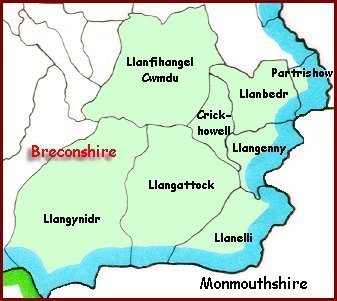
The
population of this corner of Breconshire changed
throughout the Victorian period as people moved about to earn a living.
Information about the local population was recorded in the censuses
which were taken every ten years.
Men were employed to travel round the district recording who lived in which house and what they did. The population graphs were put together from these records.
Britain was divided into parishes (shown on the map) and the figures record how many people lived in the parish. The three border parishes of Llangynidr, Llangattock and Llanelli included growing industrial communities like Brynmawr. Later in the Victorian period the parish boundaries were redrawn.
Choose from the list below to see graphs of the population of local parishes in the Victorian period.