Builth and district
Victorian maps
  Llanelwedd in 1840  
 

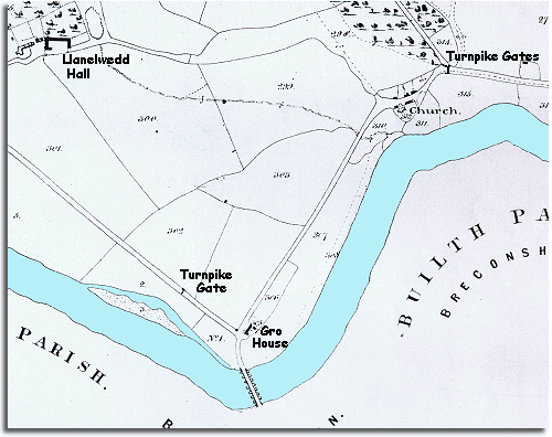
The image below is based on the tithe map for Llanelwedd parish around 1840 for the Church authorities. At that time everyone had to pay a tithe or tax to the church based on how much property they owned. The more a person owed the more they had to pay. The maps were designed to record who owned what, and they give us a lot of information about the community at the time.

 
  map of Llanelwedd in 1840
  The first thing to notice is the turnpike road coming down the valley from Rhayader. At the beginning of Queen Victoria's reign the road follows the river and comes close to the bridge over to Builth. This area across the river from the town was to become a busy area but at this time there is only Gro House standing alone.  
  The hamlet of Llanelwedd itself is very small consisting of no more than the church, a scatter of cottages, and the tollgates across the main roads to Llandrindod and New Radnor. (To find out more about the tollgates visit the Transport pages)  
 

Llanelwedd Hall stands alone in its own grounds, the home of a local landowner who would have been an important man in 1840. Today the area around the Hall is the site of the Royal Welsh Showground.

Compare with Llanelwedd in 1888


Back to the Builth maps menu

Back to top
Go to Builth menu