Brecon and district
Victorian maps
  Llanfrynach in 1840  
 

The map below is based on the tithe map of 1840, and it gives us an idea of the community in the early years of Queen Victoria's reign.
At the centre of the map we can see the small community of Llanfrynach clustered around the parish church on the bank of the river.

The original map was not aligned with north at the top, so we have turned it round to make it easier to compare with later maps.

TITHE MAPS
In Victorian times almost everyone had to pay tithes to the Church of England. At the beginning of the reign the tithe became a tax on your property. The maps were drawn to see what property everybody had
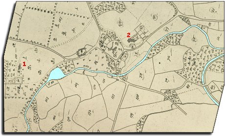

Llanfrynach tithe map
  On the eastern side of the map you can see the curve of the Brecon and Abergavenny canal. Having this close by must have been a real benefit to local farmers who could bring in lime by canal barge to spread on the fields. (To find out more about the canal visit the transport pages).  
  Two of the large houses are numbered on the map. No. 1 is Maesderwen standing in its own grounds. This was home to Mr de Winton, his family, and 9 servants. No 2 is Ty Mawr.  
  The 1841 census tells us who was living in the village at this time and what they did for a living. As well as the farmers, farm workers and servants there were many others in the community.  
  There were:- 2 gardeners, 3 millers, 2 carpenters, 3 shoemakers, 2 blacksmiths, a cooper, a tailor, a dressmaker and a miner.
The Victoria Inn and the White Swan were both listed on the census and young William Havard (aged 20) is listed as a schoolmaster.
.
 
  Compare with Llanfrynach in 1886...  
 

Back to Brecon maps menu


Link to sources
Back to top
Go to Brecon menu