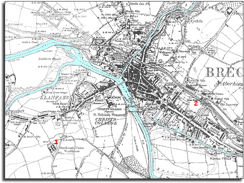
The image below is taken from a map of the area published later in Queen Victoria's reign in 1886. The map was made at a scale of 6 inches to 1 mile, so it is more detailed than the 1832 map.
| Brecon in 1886 | ||
|
The image below is taken from a map of the area published later in Queen Victoria's reign in 1886. The map was made at a scale of 6 inches to 1 mile, so it is more detailed than the 1832 map. |
||
|
|
|
|
| The map reveals that Brecon has not changed dramatically, but you can see that there has been building along th Watton and east of the Honddu. | ||
| 1. A new workhouse has been built outside Llanfaes to look after the poor of Brecon and a large area around it. (To find out more see the pages on Brecknock Union Workhouse.) | ||
| 2. Brecon is now connected to the great Victorian railway network. This helped local people as it meant that some raw materials were cheaper, and farmers and local businesses could sell their wares in far off towns and cities. Cheaper good coming into the area by rail put some local tradesmen out of business however. (To find out more see the pages on transport in the area). | ||
| Compare with Brecon in 1832... | ||
|
|
||