| |
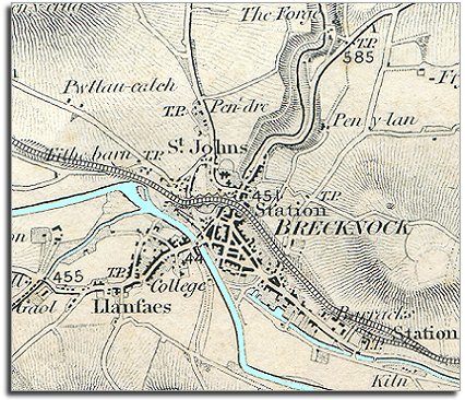
The way the
map is shaded gives us a very good idea of the shape of the landscape. From
this you can see that the town grew up at a meeting
of routes where the River Honddu flows into the Usk at a bridging
point. The castle was originally built to defend the town and
control these routes. |
|
| |
The map shows
us the importance of the river valleys
as routeways in this mountainous area. The canal, the road and the railway
each come into the town along the Usk valley. Even the road to the north-east
leaves the town along the gorge of the Honddu at first.
Notice that the roads into the town were all turnpike
roads and had toll gates (marked
T.P) where
travellers with animals had to stop and pay a fee. |
|
| |
The map shows
evidence of small scale industrial activity. To the north of the town you
can see the forge where iron was smelted.
This had fallen into disuse by the Victorian period.
On the canal side in the bottom right-hand corner you can see the lime
kilns where limestone was heated to make powdered lime to spread
on the fields. |
|
| |
Compare
with a map of Brecon in 1886... |
|
| |
Back to Brecon maps
menu
|
|
|
|
|
|