
The Elan Valley dams
The 'Welsh Lake District'
A chain of man-made lakes
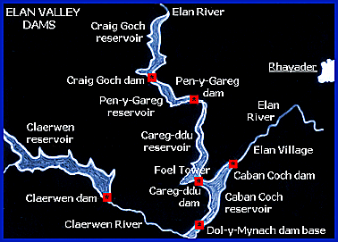
The sketch map below illustrates the relatively complex series
of linked reservoirs which produced the 'Welsh Lake District'
landscape that can be seen today. This map should be helpful
as a reference source to the pages on the history of the dams.
The area represented below measures some 9 miles (14.5 km) from west to east, and around 6.5 miles (10.5 km) from north to south, although the total area secured for the ambitious project covered over 71 square miles.
Location map
showing the dams
and reservoirs
west of Rhayader
Powys
County Archives
The Elan Valley Visitor Centre is at
the head of the valley on the B4518 approach road from Rhayader.
It has tourist information, displays, and a shop and cafe.
This sketch map may be compared with the relief
model made during the planning stages of the waterworks scheme
in 1891.
The complex network of railways and roadways which were an essential
part of the huge site are not shown here for reasons of clarity.
All of the dams and reservoirs are served today by narrow but well surfaced roads, some of which were built on the trackbeds of railways used during the construction work.