Hendomen: the Motte and Bailey Castle
at Montgomery
by Nixon Oliver

Standing alongside the narrow lane which links the minor roads B4385 and B4388, leading out of the old borough of Montgomery, is the site of a motte and bailey timber castle which played a very significant part in the history, formation and naming of the present day county of Montgomeryshire. A little to the east of this site is Offa’s Dyke, running from North to South, a man made feature which here represents the boundary between Shropshire and Montgomeryshire and also the national boundary between England and Wales.

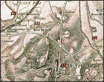
Detail of a 19th century 1" OS map

(1) Hendomen
(2) Rhydwyman
 
(3) Town of Montgomery
(4) Line of Offa's Dyke

Powys County Archives

 
At the time of the mottes’ construction there was no defined boundary as we know it today; the areas’ pre-Norman occupants were Saxons, the area described as "a hunting ground in the wilderness" and from the Doomsday writings we learn it was in the hands of three Thanes named Sennar, Oslac and Azor. We are also told the area was Witentreu - a part of the modern day parish of Chirbury. Many names in this locality are still recognisable in current place and farm names, e.g. Etenhope - Edenhop; Hoptune - Hopton; Westune - Weston; Torneberie - Thornbury; Fortune - Forden and Editrune - Edderton. It was here Roger de Montgomery built his timber castle some time after 1070AD as a forward military outpost from Shrewsbury, of which town William the Conqueror had created him Earl; he was also made Earl of Arundel. Between Shrewsbury and Montgomery there are still remains of some dozen smaller mottes in this vale of Montgomery - Caus to Hendomen. These defensive posts of earth and timber were quickly thrown up - probably by local forced labour.
  There are 7 pages on the norman origins of Hendomen. Use the box links below to view the other pages