Talgarth and district
Victorian maps
  Llangorse in 1842  
 

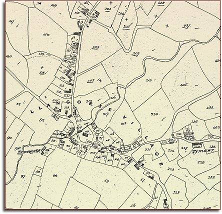
The map below is based on the tithe map for the parish of Llangorse and it shows us the layout of the village in the early years of Queen Victoria's reign.
We can see from the map that this was a well developed village which has grown up where several roads meet.


TITHE MAPS
In Victorian times almost everyone had to pay tithes to the Church of England. At the beginning of the reign the tithe became a tax on your property. The maps were drawn to see what property everybody had.
  The parish church in its churchyard can be seen at the centre of the village next to the Cui brook.  
  Notice how houses have been built along the road to the north to Talgarth, each with its own garden plot.  
  The 1841 census gives us information about the parish around this time. We know that there were 4 masons, 2 coopers, 2 tailors, 5 blacksmiths, 2 carpenters, 2 cabinet makers, 3 wheelwrights, 1 milliner and 1 weaver.
The Red Lion was run by William Morgan and the miller in the village was Samuel Griffiths, who was still working at the age of 70. Llangorse was a thriving community and all of these tradesmen and women had a role to play.


Back to Talgarth maps menu

Link to sources
Back to top
Go to Talgarth menu