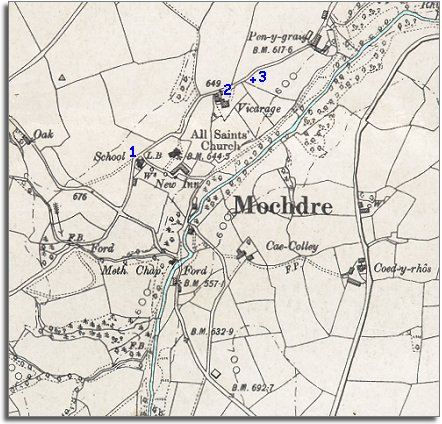
The map below is a section of a map made at a scale of 6 inches = 1 mile in 1903. It shows what changes there have been in Mochdre during the long reign of Queen Victoria.
| Mochdre in 1903 | ||
|
The map below is a section of a map made at a scale of 6 inches = 1 mile in 1903. It shows what changes there have been in Mochdre during the long reign of Queen Victoria. |
||
|
||
| There
have not been dramatic changes to the map but important changes have taken
place. By comparing the two maps for Mochdre you can see that some of the
buildings along the river have gone. This reflects the closing down of the
local water-powered woollen industry. (See the population
graph). As well as this important change the map does show other changes. |
||
| 1. As at Betws Cedewain and hundreds of other small communities across Powys a new village school has been built. By the time this map was made all local children got an education. This gave all the children a better awareness of the world outside and new skills like reading and writing. For a few children this opened up new opportunities when they were older. | ||
| 2. A comfortable new vicarage has been built along the lane from the church | ||
| 3. At this point on the tithe map of 1839 stood a cottage called Ty'n y wtre. By the end of the Victorian period the house and its occupants have gone. | ||
| Compare with Mochdre in 1839.. |
|
|
||