Newtown and district
Victorian maps
  Mochdre in 1839  

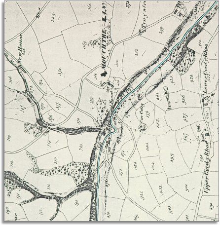
The map below is based on a detail from the tithe map for Mochdre parish and it gives us a picture of the village in the early years of Queen Victoria's reign. Look below to find out more.

The original map was not aligned with North at the top so we have turned it round to make it easier to compare with later maps.

TITHE MAPS
In Victorian times almost everyone had to pay tithes to the Church of England. At the beginning of the reign the tithe became a tax on your property. The maps were drawn to see what property everybody had
.
  Mochdre parish is a rural parish stretching right up to the Radnorshire border. Although most people in the parish would be working on the land in some way the map above shows us that local people at this time were harnessing the power of the river.
Along the lower half of the river in its steep dingle you can see water powered mills using the power of the river itself to work machinery. Most communities had a cornmill in Victorian times but some - like Mochdre - also had water powered wool mills.
 
  The 1841 census tells us about the people living and working here.  
 
Throughout this small community are people with a role in the making of cloth. Some are living in the premises at Lower Factory, Middle Factory, Lower Fulling Mill and Middle Fulling Mill. Others are living in nearby cottages or lodging on farms.
There are weavers, spinners, fullers, slubbers and carders all contributing to the finished product. (See the page on Mochdre census figures to see evidence for the failure of this local industry).
Besides these workers in the woollen industry there were also:
2 shoemakers, a blacksmith, and a mason,
 
  Compare with Mochdre in 1903..  
 

Back to the Newtown maps menu

Back to top
Go to Newtown menu