Newtown and district
Victorian maps
  Kerry in 1842  

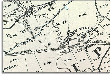
The map below is based on a detail from the tithe map for Kerry parish and it gives us a picture of the village in the early years of Queen Victoria's reign. Look below to find out more.

The original map was not aligned with North at the top so we have turned it round a little to make it easier to compare with later maps.

TITHE MAPS
In Victorian times almost everyone had to pay tithes to the Church of England. At the beginning of the reign the tithe became a tax on your property. The maps were drawn to see what property everybody had
.
  This beautifully drawn map of 1842 shows us clearly that the village has developed along an important road from the heart of Montgomeryshire over the hills and into Shropshire. We can see that the cottages and buildings have been built along the roadside on either side of the ancient churchyard.  
  Dolforgan - at the centre its large estate - is clearly market to the North of the map. The driveway to the house can be seen flanked by mature trees running down to the main road at the end of the village.  
  This large upland parish has always been a rural one (with its own breed of sheep!) In early Victorian times the great majority of local people would have worked on the land in some way. The census returns of 1841 show us who else was making a living here around this time.  
 
In Kerry and the surrounding area there were:-
3 butchers, 8 shoemakers, 3 carpenters, 4 masons, 2 carriers, 3 sawyers, 2 innkeepers, a wheelwright, a saddler, a tailor, a joiner, a bricklayer and a draper.
There was a school run by a Mr. and Mrs. Davies. This would have been a school for people who could afford a small fee so not many farm labourers' children would have gone to it.
 
  Compare with Kerry in 1903..  
 

Back to the Newtown maps menu

Back to top
Go to Newtown menu