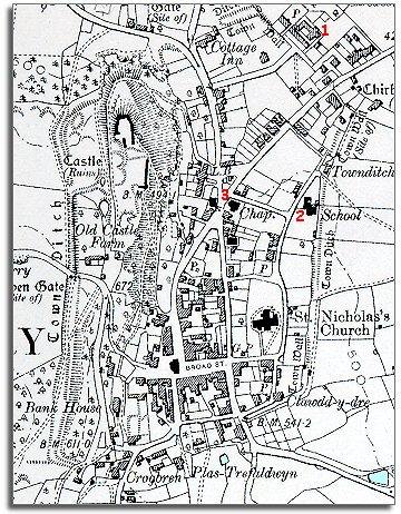
The map below is a section of a map
made at a scale of 6 inches to
1 mile in 1901.
The map shows some of the changes which have come to the town during the
long reign of Queen Victoria.
| Montgomery in 1901 | ||
|
The map below is a section of a map
made at a scale of 6 inches to
1 mile in 1901. |
||
|
|
|
|
| 1. The County Gaol has closed though part at least of the building is still in use as housing in 1901. | ||
| 2. A new school has been built on the eastern edge of the town against the old town ditch. Although there were schools in Montgomery at the time of the tithe map, by the end of Queen Victoria's reign all children received an education and had to go to school. This began to offer children better opportunities for work when they left school. | ||
|
3. A new chapel has been built at the crossroads. There were nonconformist chapels here before this but the trend has continued, offering local people another way of worshipping. These chapels also were important centres for organising many other social activities for their members. |
|
|
|
|