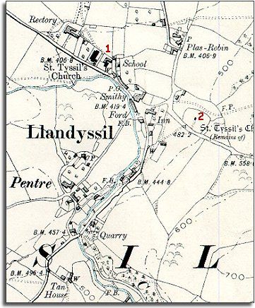
The map below is a section of a map
made at a scale of 6 inches to
1 mile in 1903.
The map shows what changes there have been in the village of Llandysul
during the long reign of Queen Victoria.
| Llandysul in 1901 | ||
|
The map below is a section of a map
made at a scale of 6 inches to
1 mile in 1903. |
||
|
||
| The village has not changed dramatically on the map but there have been some changes. Compare with the tithe map to see some of these. | ||
| 1. Next to the Rectory at the top of the village there has been some building. Llandysul has a new parish church for its congregation, and next to that is a new village school. By the time this map was made all local children got an education. This gave all the children a better awareness of the world outside and new skills like reading and writing. For a few of them this opened up new opportunities when they were older. | ||
| 2. The old churchyard is now just marked as "remains". | ||
| If you look closely at the map you will see other changes. Can you spot any ? |
| Compare with Llandysul in 1843... | ||
|
|
|
|