Montgomery and district
Victorian maps
  Llandysul in 1843  
  The map below is based on a detail from the tithe map for Llandysul parish.  

TITHE MAPS
In Victorian times almost everyone had to pay tithes to the Church of England. At the beginning of the reign the tithe became a tax on your property. The maps were drawn to see what property everybody had
.

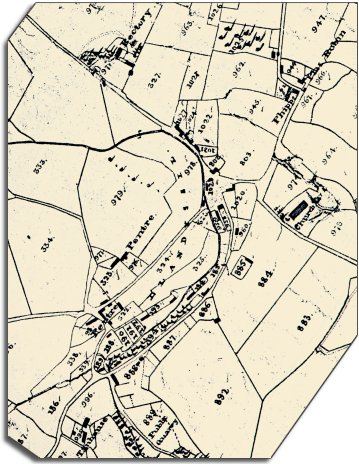
Although the original is tattered and faded it gives us a picture of the village in the early years of Queen Victoria's reign.
We can see from the map that there is a scatter of smaller cottages near the stream, especially at Pentre.
The bigger houses like the Rectory and Tan House stand apart with more space around them.
This looks like a typical small rural Montgomeryshire community. Most of the people living here would have made their living on the land in some way.
The 1841 census (see below) shows us however, that there were many other people working in this small community...

 
  Across the parish of Llandysul there were:
2 dressmakers and a seamstress, 2 shopkeepers, 10 shoemakers, 9 charwomen (cleaners), 6 millers, 8 wheelwrights, 8 blacksmiths, 3 tailors, 2 sawyers, 2 carpenters, 2 surgeons.
There were also a number of people working in the production of wool - fullers, carders and slubbers.
The Bryn Derwen turnpike gate was in the responsible hands of Margaret Rheese, aged 15.
The original map was not aligned with north at the top, so we have turned it round a little to make it easier to compare with later maps.
 

One other feature of rural areas with a small population is the number of people who did more than one job to make ends meet. John Edwards of Llandysul was a publican, shopkeeper and shoemaker, and George Roberts of Abermule Mill was a miller, maltster, and farmer.

Compare with Llandysul in 1901 ...


Back to Montgomery maps menu


Link to sources
Back to top
Go to Montgomery menu