Machynlleth
Some Victorian maps
  Llanwrin in 1903  
 

map of Llanwrin in 1903


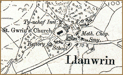
This enlarged section of an Ordnance Survey map is from 1903, and it shows the hamlet at the end Queen Victoria's reign. If you compare it with the 1837 map (click here to see it) you can see some of the changes that have occured.
The community still has a blacksmith working in his smithy (marked Smy.) and the Ty-uchaf Inn is still going strong.
Some of the tiny cottages in rows on the earlier map appear to have gone. Does this mean there were fewer people living in the area ? Visit the pages on the population of the area in Victorian times for the answer.


There are new features in the village:-
P.O indicates a new Post Office. Now that more people can read and there is more travel, more letters are being written and even the smallest communities need a Post Office.
The village has a school in 1903, and all the local children are now taught to read and do arithmetic. This means that some of them at least will be able to get better jobs when they grow up. In 1837 probably only the vicar's children had a proper schooling.
As well as St. Gwrin's parish church, the village now has a Methodist Chapel (marked Meth. Chap.) where local people could worship in a different way and probably in the Welsh language.

Compare with Llanwrin in 1837...


Back to Machynlleth map menu