| |
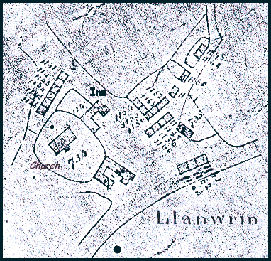
This enlarged section of an old map
dates from 1837, the year Queen Victoria
came to the throne.
It was made by men working out how much tax each property owner owed to
the church. Each house was given a number, and the owner's name was written
in a large book. One feature of this rough map is the number of tiny cottages
there were in the village.
Just a few years later a census
was taken and we know that in this small hamlet in
1841 there were -
2 tailors,
2 shoemakers, 1 miner
(aged 15), 1 blacksmith
(with a wife and 5 children), 1 wheelwright
(making cartwheels), 1 currier
(staining leather hides), 1 shopkeeper,
and many others who worked in the local farms.
The innkeeper was Richard Griffiths and the vicar (with
a houseful of servants) Reverend Isaac Bonsall.
Compare
with Llanwrin in 1903...
|
|
