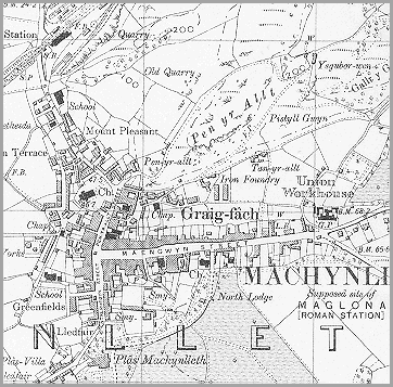
It shows Machynlleth at the end of Queen Victoria's reign and reveals some of the changes to the town in that period.
Notice the development to the north side of Maengwyn Street where a foundry is working at the foot of Pen yr Allt and another chapel (marked Chap.) has been built.
Notice also the Machynlleth Union Workhouse at the eastern end of Maengwyn Street. (See the pages on the workhouse for more information).
As well as the National School in Doll Street the Intermediate or County School is shown behind Pentrerhedyn Street by Greenfields.
Perhaps the most significant change
can be seen in the top left of the map where the railway
station is indicated.
The coming of the railway in the 1860s
made a huge improvement in communication and travel. Local products could
be sold in far away places which helped local businesses and created jobs.
Goods from all over the British Empire were brought in by rail and sold
in local shops.