| Comins Coch in 1903 | ||
|
|
|
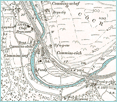
The above map is an enlarged section
of an Ordnance Survey map produced at the end
of Queen Victoria's reign. |
||
|
The
railway has come to the area,
using the same valley as the road. This put Machynlleth and the small
local communities in contact with towns and cities far away. Building
it took tremendous organisation and labour.
In this small stretch of the valley the Cambrian railway crosses the river twice. This is because the railway cannot turn sharp corners, so engineers have to use cuttings and bridges to make the line go round a smoother bend. |
||
|
The map above also shows that the
hamlet has a school at the roadside.
By the end of Queen Victoria's reign all the local children would have
had an education up to 13. Most local children would spend their school
lives in this one tiny building. |
|
|
||