 Powys
County Archives
Powys
County Archives| Abergwesyn in 1888 | ||
|
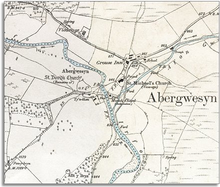
The map below is a section of a map made at a scale of 6 inches = 1 mile in 1903. Abergwesyn village is still a tiny community and does not look dramatically different from the village we can see on the 1940s map. Even so we can see that there have been some changes to the hamlet since the map of 1833 was made. |
|
|
Powys
County Archives |
|
| Across the river from the ruined medieval church of St David is the church of St michael which was rebuilt in 1871. Nearby is the Moriah chapel rebuilt in 1867 by the Independents. A choice of worship was available to local people. | ||
| There was a schoolmaster in Abergwesyn in 1841 but what sort of school he ran is not known. The map above shows the new school built sometime between 1865 and 1870. It was a corrugated structure known as the Iron Room. It was partly paid for by the Thomas family of Llwynmadog and other landowners and was a church or National School. (To find out more about schools in the area click here). | ||
| Compare with a map of the area in 1833.. | ||
|
|
||