 Powys
County Archives
Powys
County Archives| Abergwesyn in 1833 | ||
|
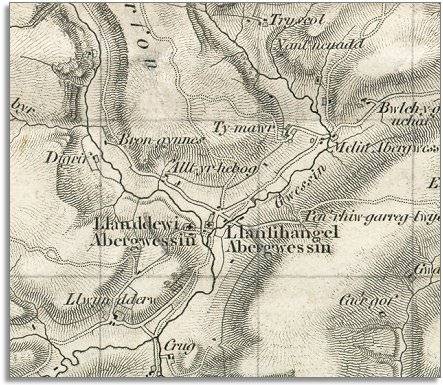
Below is a small part of a larger
map made by the surveyors of the Ordnance Survey
in 1833. The map shows that this community formed where two routes crossed. The road running from the north-east along the Gwesyn valley and away to the south connects Abergwesyn with Beulah and Llanwrtyd, and leads beyond to the larger roads to distant places. |
|
|
Powys
County Archives |
|
|
The road coming from the top of the map is the steep mountain road from Cardiganshire. It continues from Abergwesyn eastward over the slopes of Pen-rhiw-garreg-lwyd. This is the way the drovers brought their beasts on the long journey to English markets. Most people living in the area at this time were involved in working on the land in some way. They were farmers, farm labourers or servants, shepherds and the like.In 1841 the hamlet also had a tailor, a weaver and 2 masons. The Grouse Inn was then looked after by the 80 year old John Williams. |
||
| Compare with a map of the area in 1888.. | ||
|
|
||