
TITHE MAPS
In Victorian times almost everyone had to pay tithes to the Church of England. At the beginning of the reign the tithe became a tax on your property. The maps were drawn to see what property everybody had
 Powys
County Archives
Powys
County Archives| Llangamarch around 1840 | ||
|
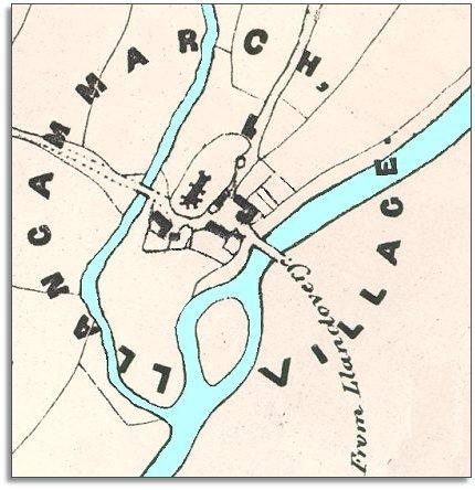
The map below is based on a detail from the tithe map and it gives us a picture of this community in the early years of Queen Victoria's reign. The community was very small but grew up around the parish church at the heart of the old parish of Llangammarch where two rivers met (Rivers Cammarch and Irfon). The map is of the Treflys part of the parish and so does not show the couple of buildings over the river to the South at that time. |
|
TITHE MAPS In Victorian times almost everyone had to pay tithes to the Church of England. At the beginning of the reign the tithe became a tax on your property. The maps were drawn to see what property everybody had |
Powys
County Archives |
|
|
In 1841 alost everyone in the area
was involved in working on the land in some way. Most were farmers, farm
labourers or servants. There were also shepherds and drovers. There were
also 2 carpenters, 3 miners,
1 grocer, 2 tailors,
2 blacksmiths and a saddler. |
||
| Compare with a map of the area in 1888.. | ||
|
|
||