| Llangynog in 1902 | ||
|
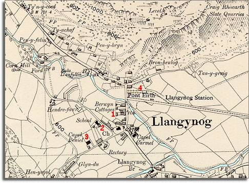
The map below is a section of a map
made at a scale of 6 inches to
1 mile in 1902. |
|
|
1. The village has expanded and a new row of larger cottages "Berwyn Cottages", has been built on the road to the bridge. 2. A fine new school has been built for local children. By the end of Queen Victoria's reign all children received an education. This was very important for the children of the ordinary working families. The new school offered these children more opportunities when they grew up. Instead of having limited job possibilities, children were given enough education to enable some of them to do something different with their lives. 3. A new chapel has been built in the village. The Victorian period saw a great rise in the number of chapels as communities set up new places of worship where they could worship in their own way and in their own language. 4. The railway has reached Llangynog connecting this relatively remote upland community with the great railway network. This would help the slate and other local industries, allowing goods to be taken to far off places. It also allowed new travel opportunities to those who could afford it. |
|
|
|
|