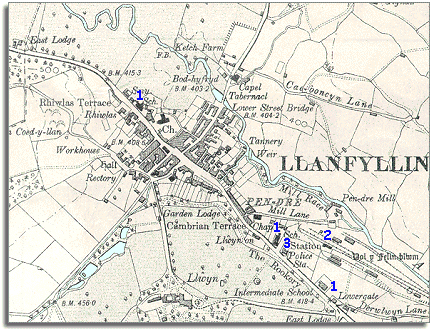
Llanfair and district
Victorian maps
  Llanfyllin in 1902
Glossary
 

The map below is a section of a map made at a scale of 6 inches to 1 mile in 1902.
Although the town has not changed dramatically, on the map we can see some of the changes which have come during the long reign of Queen Victoria.

compulsory - something that had to be done.
 
  Llanfyllin in 1902
 

1. The map shows three schools in the town in 1902 (all marked 1 here). Although there were schools in the town at the time of the tithe map, by the end of Queen Victoria's reign all children received an education and going to school was compulsory.
The Intermediate School (now the Library) offered a secondary education for more able older pupils, but many parents from poor families still could not afford to keep their children on at school beyond 14.

2. The railway has come to Llanfyllin. (See pages on Transport).
With the opening of the station in 1863 the town and surrounding area were connected with a great railway network. This made travel across the country and the transporting of goods much easier. Cheaper goods came into the area from further off which helped poorer local people, but this also put some local craftsmen out of work.

3. A fine new police station has been built with a house for the policeman and his family, and a station with two cells.

Compare with Llanfyllin in 1850...


Back to Llanfyllin maps menu

Back to top
Go to Llanfyllin menu