| Population figures for Knighton parish | ||
|
|
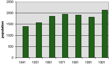
| The actual recorded figures for the population of the parish were:- | ||
| In
the year 1841 - 1404 people In the year 1851 - 1566 In the year 1861 - 1853 In the year 1871 - 1946 In the year 1881 - 1905 In the year 1891 - 1813 In the year 1901 - 2139 |
||
| The
parish of Knighton includes the town and farmland around it, stretching
from Knucklas in the west to Milebrook in the east. (To find out what the people of the town did for a living see the pages on Earning a Living). The government report which published the figures also tells us that Knighton workhouse had 54 paupers in 1841 and 90 in 1851. Notice that the population rose quite steeply around 1901 after declining since 1871. |
||
| Compare
this graph with those of the rural parishes in the area like Beguildy or
Stanage. Then compare them with other towns like Builth or Rhayader. Is the overall trend the same? If the trend differs, in what way does it differ? What project was happening across the area which might explain the rise in population in 1901? |
|
Back to Knighton population menu
|
|
|