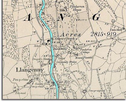
Below is a detail from a map made in 1904 just after the end of Queen Victoria's reign. It is more detailed than the 1872 map and can show us some of the ways in which the community has changed.
| Llangenny in 1904 | ||
|
Below is a detail from a map made in 1904 just after the end of Queen Victoria's reign. It is more detailed than the 1872 map and can show us some of the ways in which the community has changed. |
||
|
||
| The paper mill to the South of the church on the riverside is now marked as disused. By this time steam powered mills had replaced many water mills and the workers had to move away to find work. | ||
|
The photograph left shows the house and grounds at about this time. |
||
|
Next to the church on the map you can see that the village now has a school. This was a very important change in the community as the education children got here gave them a chance to do a wider range of jobs in later life. |
 Across
the river from the church the map shows the shaded area which is the park
belonging to Pendarren House. Big houses like this needed servants to
run the house and gardens and many local people went into
service.
Across
the river from the church the map shows the shaded area which is the park
belonging to Pendarren House. Big houses like this needed servants to
run the house and gardens and many local people went into
service.