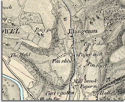
The image below is taken from an old map published in 1872. The way the map makers shaded the map gives us a good idea of the shape of the hills. From this we can see Llangenny was a very small rural settlement in the valley of the Grwyne Fawr.
| Llangenny in 1872 | ||
|
The image below is taken from an old map published in 1872. The way the map makers shaded the map gives us a good idea of the shape of the hills. From this we can see Llangenny was a very small rural settlement in the valley of the Grwyne Fawr. |
||
|
||
| The map shows us that in the middle of Queen Victoria's reign the fast moving waters of the Grwyne Fawr were being used to power two paper mills. The water would turn a mill wheel and a system of wheels and cogs attached to that would drive the machinery. As long as there was enough water in the river the mill could keep going. | ||
 Llangenny church and houses in late Victorian times |
||
| Compare with map of Llangenny in 1904 |