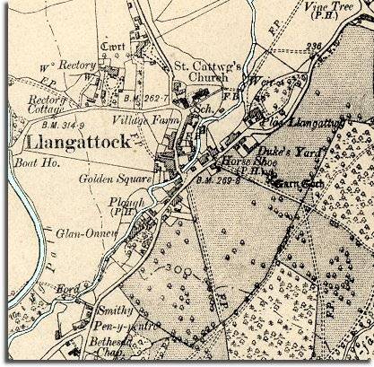
The image below is taken from a map of the area published just after Queen Victoria's reign in 1904. The map was made at a scale of 6" to 1 mile so it is more detailed than the 1872 map.
| Llangattock in 1904 | ||
|
The image below is taken from a map of the area published just after Queen Victoria's reign in 1904. The map was made at a scale of 6" to 1 mile so it is more detailed than the 1872 map. |
||
|
||
| Again we can see the large shaded areas of park land. The great houses were still very important to the local community and their owners were important men in the county. | ||
| Next to the parish church we can see the village school (marked Sch.) Learning to read and write and do basic arithmetic gave children a chance of better job opportunities when they left school. Even so a great many children would still grow up to work on the land or go into service. (See the pages on local School Life to find out more.) | ||
|
Although the canal can still be seen on the map its importance as a means of transporting coal and other materials is over. The development of railways across the country spelled the end of the of the canal age. |