Crickhowell and district
Victorian maps
  Llangattock in 1872  
 

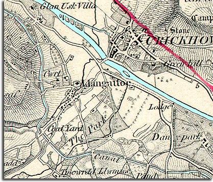
The map of Llangattock below shows the village of Llangattock and the surrounding area in the middle of Queen Victoria's reign. Situated at a crossing point on the river Usk, the village was always close enough for people to work in the town of Crickhowell and visit the market.


  The canal was important to Llangattock in earlier Victorian times. As canals could only go uphill through a series of locks, the engineers who built them followed the contours of the landscape to keep the canal as level as possible. This meant that the canal came through Llangattock rather than Crickhowell. You can see the coal yard next to the canal where barges of coal could be unloaded and the coal transported to households by cart.
Nearby were lime kilns where limestone could be baked into lime. The limestone was brought down from the hills by tramway.
 
  The map also shows the grey shaded areas of the parkland around the great houses. With dramatic mountains on both sides of the valley the area attracted many landowners who set up estates locally. Many farmers in the area were tenants of these estates, and many local people were farm workers and servants on them.  
  Compare with a map of Llangattock in 1904  
 

Back to the Crickhowell maps menu

Back to top
Go to Crickhowell menu