| |
At
the top of the map you can see a new row of houses
along the Llanbedr Road which were not there in 1872. The Eastern side of
High Street has also been filled in with new buildings, especially shops. |
|
| |
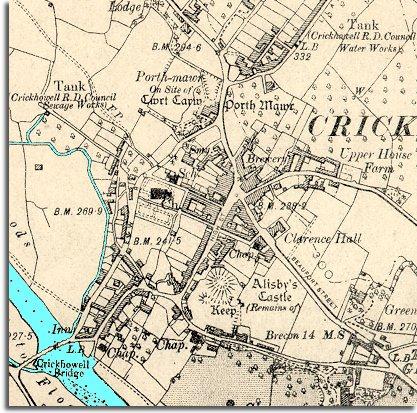
On
Beaufort Road there is a new public hall for the community. This is the
Clarence Hall opened in 1892. The hall
was to be an important meeting place in the town for many years to come. |
|
| |
In
the top left of the map you can see that the town now has a proper sewage
works. This is very important for the health of the people of
the town. In Victorian times before proper sewage treatment the waste from
toilets often drained straight into the rivers. By 1904 the town also had
a good supply of clean water. |
|
| |
Compare
with map of Crickhowell in 1872 |
|