Crickhowell and district
Victorian maps
  Crickhowell in 1872  
 

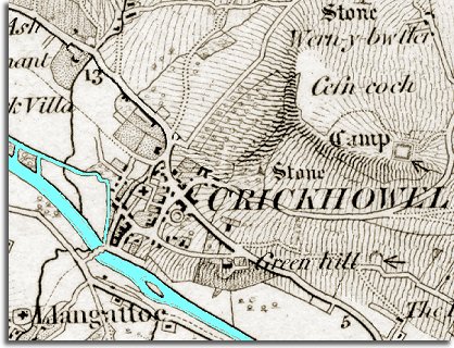
This is an extract of a map published in 1872. It gives us some idea of how the town of Crickhowell must have looked in the mid period of Queen Victoria's reign. The map's shading shows the shape of the landscape, especially the hills to the North East of the town. From this picture of the landscape you can see how the town grew up where a major road from England up the Usk valley to Brecon passed a crossing point on the river.

 
  map of Crickhowell in 1872
  The town itself is much smaller than it is today. On the right hand side of High Street (the eastern side) there are only a few houses and there is much empty space around the church (marked as a cross).  
  The town would be the market centre for the area, where people would come to sell their produce. Local tradesmen would sell their wares in the shops and inns would provide accommodation for travellers. (See the pages on the old Trade Directories to find out who was living and working in the town in Victorian times)  
  Compare with map of the town in 1904  
 

Back to the Crickhowell maps menu

Back to top
Go to Crickhowell menu