Brecon and district
Victorian maps
  Merthyr Cynog in 1840  
 

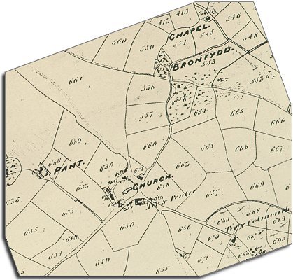
The map below is based on the tithe map of 1840, and it gives us an idea of the community in the early years of Queen Victoria's reign.
From the map we can see that Merthyr Cynog itself was a cluster of buildings around the church. Most people in the parish lived in scattered farms and holdings. This is a settlement pattern common in the upland areas of Powys.

The original map was not aligned with north at the top, so we have turned it round to make it easier to compare with later maps.

TITHE MAPS
In Victorian times almost everyone had to pay tithes to the Church of England. At the beginning of the reign the tithe became a tax on your property. The maps were drawn to see what property everybody had


Merthyr Cynog tithe map
  The chapel at the top of the map is Siloah Methodist chapel. This meant that local people in this remote upland area had a choice of worship. They could attend the chapel or the parish church.  
  Most of the local people in early Victorian times would have worked on the land in some way. The census returns for 1841 tell us who was living here and what else they did for a living.  
  In the village and the wider parish (including Upper Chapel) there were 4 blacksmiths, a tailor, a bookbinder, 2 coopers, 2 masons, 4 carpenters, 2 masons, a publican and a tollgate keeper.
In the village of Merthyr Cynog itself the blacksmith who kept his forge across from the church was Thomas Price.
.
 
  Compare with Methyr Cynog in 1887...  
 

Back to Brecon maps menu


Link to sources
Back to top
Go to Brecon menu