Brecon and district
Victorian maps
  Defynnog and Sennybridge in 1837  
 

The map below is based on the tithe map of 1837 and gives us an idea of these communities in the year Queen Victoria came to the throne.
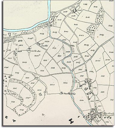
From the map we can see that Defynnog grew up on the road to the communities of SW Breconshire and the port of Swansea beyond. As its name suggests, Sennybridge developed at a convenient crossing point over the River Senni where it flows into the Usk.


TITHE MAPS
In Victorian times almost everyone had to pay tithes to the Church of England. At the beginning of the reign the tithe became a tax on your property. The maps were drawn to see what property everybody had

detail from tithe map

Two areas on the map appear to be empty. They weren't really !

The areas to the north of the River Usk, and west of Defynnog village were not in the same township.
Because this was a tithe map of Maescar they were not included on this map.

  The census returns for 1841 tell us something of what was going on in the area at the time.
Defynnog was a thriving little community with a number of busy craftsmen (and women). There were 3 weavers weaving cloth and one dyer dyeing it. This was Samuel Winstone still hard at work at the age of 82!
There were 5 blacksmiths in the area (1 at 'Castle Du' on the map), 6 tailors and 6 shoemakers!
There also were tilers, shopkeepers, innkeepers and a whole host of other people earning a living here. Mr David Charles ran a school for those who could afford it.
 
  At the small community of Sennybridge just up the road there were also a number of tradesmen, including 3 maltsters making malt for brewing beer, 3 more weavers and a surgeon.
.
 
  Compare with map of the area in 1886...  
 

Back to Brecon maps menu


Link to sources
Back to top
Go to Brecon menu