| |
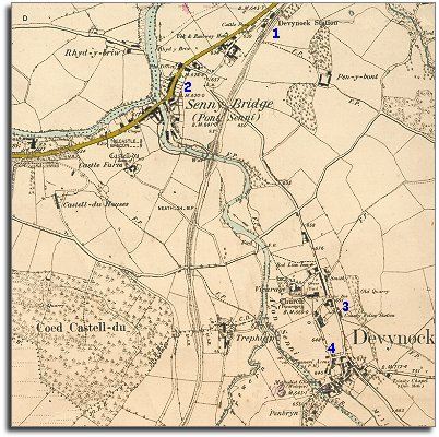
1.
Perhaps the most obvious change on this map is the Brecon to Neath railway
which is marked coming through Sennybridge and away to the south. This connected
the communities of rural Breconshire with the growing industrial towns to
the south. This meant farmers could sell their goods more easily to the
growing populations there. The little station at
Sennybridge had pens for the cattle to be kept whilst waiting
for the trains. |
|
| |
2.
The community of Sennybridge has grown
during the Victorian period, with more road and rail traffic and the prosperity
this brought. |
|
| |
3.
Defynnog has a police station.
The presence of a trained policeman helped to keep the area a more ordered
community. For more on the new police force for the area click here. |
|
| |
4.
Although there was a school
at Defynnog in 1841, by the time this map was made every child was required
to attend school until at least the age of 10. Most local children would
spend their whole school lives in this one tiny building. (To find out more
about what Victorian school life was like in the area, click here). |
|
| |
Compare
with a map of the area in 1837... |
|
| |
Back to Brecon maps
menu
|
|
|
|
|
|