Hay Castle
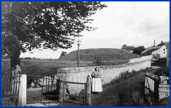
The first Norman castle, c1100
The border wars
The borderlands between England and Wales, the Welsh Marches,
were a battleground for the two nations over the centuries following
the departure of the Romans. In 784 the Anglo-Saxon King Offa
of Mercia in the English Midlands marked the boundary between
his territory and that of the Welsh by constructing the lengthy
earthworks of Offa's Dyke. The Dyke remains today a close approximation
of the present border between Wales and England.
After the successful invasion of England by William of Normandy in 1066, the king rewarded his supporters with lands along the borders of Wales. These powerful Marcher Lords were permitted to seize land from the Welsh in the 12th century, and they built motte and bailey castles, firstly of earthworks topped by timber pallisades and later rebuilt in stone, to secure the conquered lands.
The earthworks
of the first
Norman castle
at Hay
Photograph by
kind permission of
Eric Lewis Pugh
of Hay

The land around Hay was taken by the Normans around 1100,
when their first small castle on an artificial mound to the south-west
of the present town centre was constructed. This original castle
site, close to the parish church of St Mary, was abandoned around
1200 when it was replaced by a much larger stone castle built
on high ground at the centre of the town.
The old photograph shown above is of the earthworks, long referred
to as 'The Tump', near the River Wye at Hay, close to the site
of the present Cattle Market.
There are 3 pages on Hay Castle. Use the box links below to view the other pages.