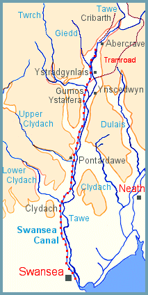
Map of
Swansea Canal
The
route of
the canal is
shown by the
blue and red
dotted line.
The River
Tawe
is alongside
the canal to
the right, and
other rivers
are named
in blue
The valley of the River Tawe was believed to have great need of a canal because coal, iron ore, and limestone were all to be found in the area "in almost inexhaustible quantities" according to a report supporting the canal proposal.
The collieries in the valley were growing, and they needed better links with the river wharves to send their coal to towns in the west of England.
There were plans to expand the ironworks at Ynscedwyn and elsewhere in the valley, and copper ore was also available for smelting.
The harbour at Swansea was being improved in 1792 to handle a huge increase in commercial goods.
All these reasons came together to bring about a survey of the Tawe Valley, and an Act of Parliament of 1794 gave authority for the Swansea Canal to be built.