| |
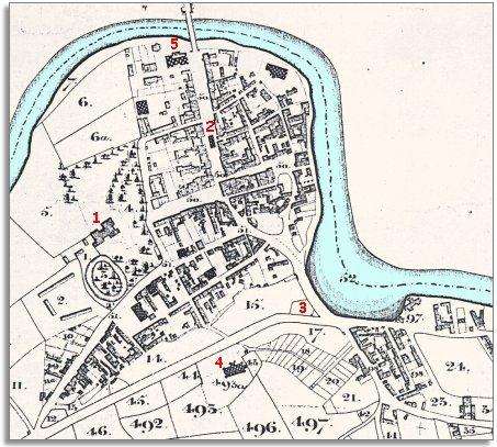
1.
Newtown Hall. At this time it was the home of the Rev. George
Evors. He was an important man in the town owning many properties including
the gardens you can see marked 18 and 19 at the bottom of the map. He also
built flannel mills and helped to develop the industry. |
|
| |
2.
The old Market Hall stood in the middle
of Broad Street. Like the market halls in Rhayader and Llandrindod it was
built in quieter times when the towns were smaller and there was not much
wheeled traffic. |
|
| |
3.
At the major road junction at the entrance to the town stands the timber
yard of Edward Morgans. |
|
| |
4.
The new church of St David which was being constructed at this time. The
old church of St Mary's on the bank of the Severn was falling into a bad
state and as the population of the town was rising fast a new church was
needed. |
|
| |
5.
The Flannel Exchange by the Long Bridge.
This was built as a market for woven cloth in 1833. At the time this tithe
map was made the industry was going through a bad patch. This was hard on
the weavers who had difficulty selling the cloth they had woven. |
|