| Census figures for Defynnog parish | ||
|
|
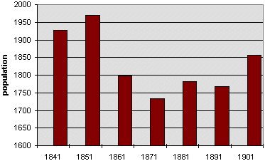
| The actual recorded figures for the population of the parish were:- | ||
| In
the year 1841 - 1927 people In the year 1851 - 1969 In the year 1861 - 1798 In the year 1871 - 1734 In the year 1881 - 1782 In the year 1891 - 1767 In the year 1901 - 1857 |
||
|
Defynnog was a large upland
parish in Victorian times. It included Cray, Maescar, Senni,
and Glyn. Later in the 19th century the parish was divided up but we have
given the figures for the whole area so that we can compare like with
like. Compare this graph with those of
other rural parishes in the area like Llanfrynach and Llandeilo'r Fan. |
|
|
||