
The edge of the valleys
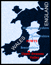
The Upper Swansea Valley lies at the southern
extremity of the 2000 square miles covered by the county of Powys.
While the northern edge of the county touches the foothills of
Snowdonia, the southern border is close to the industrial centres
of the valleys.
Most of the Breconshire part of the Swansea valley lies in
the old parish of Ystradgynlais, once an agricultural area of
about 12,000 acres. It is uncertain when coalmining first began
in the valley but iron was made at the Ynysdedwyn Iron Works
at least as long ago as the early eighteenth century.
The presence of coal and iron ore in the locality offered up
possibilities but with the development of David Thomas' hot-blast
furnace, which used local anthracite, the industrialisation of
the valley proceeded with great pace. The workers for these new
industries were housed in the small communities springing up
along the valley.
Coalmining and steel production locally eventually declined but the landscape of the valley and the outlook of its people were marked for ever by the experiences of that time.
Click on the "Continue" button to see views of the landscape